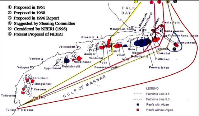
Present Proposal
Courtesy of Tuticorin Port Authority
The Defense Minister of India in 1999, George Fernandes, proposed the Sethusamudaram project to cut a traverse across the Palk Straits between Sri Lanka and India. Military planners in India developed the proposals. However, due to financial reasons the project was not implemented. Questions were raised in Sri Lanka about the impact of the project on Sri Lanka, Tamil Nadu and the shallow seas. Later in 2004, the project was revived by the DMK Minister in the India Central Government for Shipping, T. Baalu, is driving this project. Sri Lanka has largely learnt of this project through the media. The purpose of this page is to serve as a clearing house for the salient articles and links regarding this project with a focus on social and environmental impacts on Tamil Nadu and Sri Lanka.
Courtesy of Tuticorin Port Authority
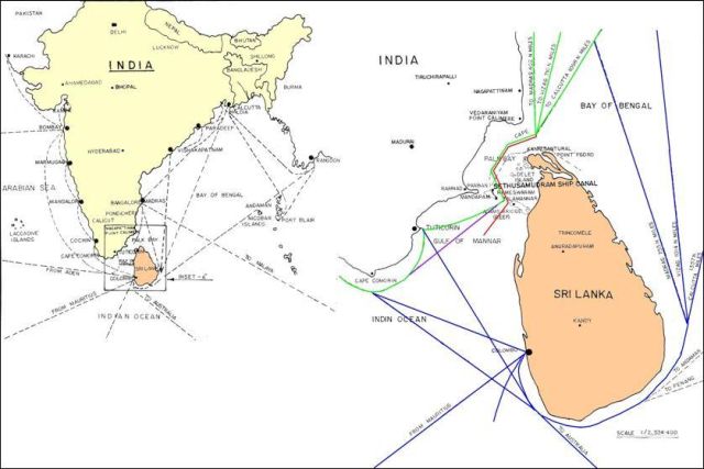
The Government of India has decided to go ahead with the Sethusamudram Ship Canal Project (SSCP) and has passed the funds necessary for its implemention. This project, which has been almost a century-and-a-half in the making, envisages linking the Arabian Sea with the Bay of Bengal by dredging the shallow waters to the North of Sri Lanka, thereby creating a navigable canal across the Gulf of Mannar, Palk Bay and the Palk Straits. These waters have hitherto not been navigable by cargo shipping, and the justification for the project is that it will save about 400 kms of sailing distance between the East and West coasts of India.
An Environmental Impact Assessment (EIA) report was prepared by the National Environment Engineering Research Institute (NEERI) of Nagpur, although it has reportedly had no previous experience with marine projects of this nature. According to the executive summary of this report, the waterway is envisaged to be 260 km in length and 300 metres in breadth. The canal has been assessed at various depths, but is likely to be 14.5 metres deep, allowing the passage of ships with a draught of up to 12.8 metres, including bulk carriers of 65,000 DWT, 240m length overall and 33m beam and container vessels of 56,000 DWT, 290m length overall and 32.2m beam. Map: Trace of SSCP (Courtesy Manitham)
In order to create this passage, two channels would have to be dredged, one across Adams Bridge (the chain of islets and shallows linking India with Sri Lanka) just South-East of Pamban island and another through the shallows of Palk Bank, deepening the Palk Straits. The total length of these two channels would be 56 kms. The initial excavations would produce in excess of 80 million m3 of dredged silt and sand and subsequent maintenance dredging to keep the passage open is estimated by NEERI to require 100,000 m3 silt/sand per year to be removed.
| Source | Title | Author | Publication Date |
| The Island | Hazards for Tamil Nadu and Sri Lanka from the excavation of the Palk Straits | Lareef Zubair | 29th March 1999 |
| Daily News | Hazards for Sri Lanka and Tamil Nadu from Sethusamudaram | Lareef Zubair | 7th Apr 1999 |
| The Island | Hazards from excavating the Palk Straits for shipping | Lareef Zubair | 5th Aug 2004 |
| The Island | Dangers Lanka and Tamil Nadu face from Sethusamudram | Lareef Zubair | 21rd July 2005 |
| Source | Title | Author | Publication Date |
| HindustanTimes | Lankan environmentalist body objects to Indian project | P K Balachanddran | 7th Sep 2004 |
| HindustanTimes | Sethusamudram project will be a boon to Jaffna, says Lankan Tamil geographe | P K Balachanddran | 3rd Oct 2004 |
| HindustanTimes | India didn't keep Lanka in dark over Sethu project | PK Balachanddran | 14th Oct 2004 |
| HindustanTimes | Sethu project will revive Jaffnas ancient maritime glory: Historian | PK Balachanddran | 18th Oct 2004 |
| Sunday Observer | A canal to riches or environmental disaster? | Rohan Canagasabey | 26th Sep 2004 |
| Hindu | Hindu Editorial | 9th Sep 2004 | |
| Deccan Herald | The Sethusamudram canal: boon or bane? | S Murari | 26th Sep 2004 |
| Business Standard | Big vessels may have to skip Lanka canal | Vishaka Zadoo | 11th Dec 2004 |
| DailyMirror | Shifting sands would create problems for Sethusamudram Channel: Survey | By L. B. Senaratne | 22nd Dec 2004 |
| The Island | WP development, Colombo Port and Sethu Samudram Project | Professor Willie Mendis | 23rd Dec 2004 |
| Economic and Political Weekly | Is the Sethusamudram Shipping Canal Project Technically Feasible? | R Ramesh | January 22, 2005 |
| The Island | The Palk Strait: Nature's bi-lateral buffer zone | Professor Willie Mendis | 23rd March 2005 |
| HindustanTimes | Tsunami casts doubts on Sethu project | P K Balachanddran | 31st Jan 2005 |
| Sunday Observer | A Bridge to progress? | Arefa Tehsin | 31 July 2005 |
| The Island | SS project: Who looks after Lanka’s interests? | Hemantha Withanage | |
| The Island | Nuclear threat from Sethu Canal | D.S | |
| Daily News | Sethu Project Disastrous | Marine Experts | 6 April 2013 |
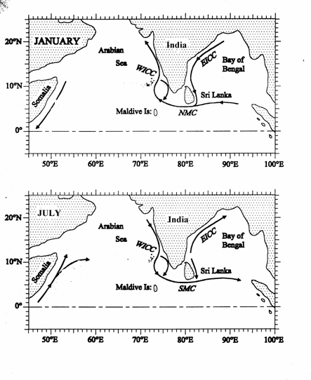
To understand, why such a short-circuit is likely, we need to know about the ocean currents in the Indian Ocean close to Sri Lanka. Here, currents that come travel along the equator, those that come from open seas and those that are driven along the coasts of India, merge, clash and set off eddies and waves. The ocean current is driven from the Bay of Bengal to the Arabian Sea during the North-East monsoon and from the Arabian sea to the Bay of Bengal during the South-West monsoon. During the NE monsoon, the East Indian Coastal Current (EICC) travels down the East coast impelled by the monsoon winds and fed by the discharge of the Ganga and other rivers along the West Coast. These currents are particularly rapid when there is heavy rains or cyclones. During the South-West monsoon, the West Indian Coastal Current (WICC) travels down the West Coast. To the South of Sri Lanka, the Equatorial Monsoon Current (EMC) flows West and East during the South-West and North-East monsoons respectively.
In computer model's of the ocean circulation around Sri Lanka a difficulty in simulating the flow around Sri Lanka is that there is no estimate of the actual volume of water that flows across the Palk Straits. When the gap between Sri Lanka and Tamil Nadu is kept closed, the regional oceanic behaviour are reproduced realistically. When a narrow channel is left open across the Palk Straits, the currents gushed rapidly through it distorting the ocean currents. Since, the sea is shallow across the land bridge from Mannar to Rameshwaram, there will be little flow across it as intuited by the model. If indeed there was a sufficiently large passage, part of the EICC and WICC will gush through the Straits.